Up Your Hydraulics Game with 12d Model + TUFLOW’s Sub-Grid Sampling and Quadtree
Bill Syme (TUFLOW Software Lead at BMT) and Rob Graham (Water Resources Engineer at 12d Solutions) presented a fantastic talk at our recent 12d Tech Forum 2021, detailing exciting new features in TUFLOW software, and their integration into 12d Model:
TUFLOW’s implementation of Sub-Grid Sampling (SGS) and Quadtree grid refinement produces quality results without the need for a small cell size throughout the entire TUFLOW grid. 12d Model 15’s integration with TUFLOW includes both features.
Both Sub-Grid Sampling and Quadtree Meshes have really allowed TUFLOW to improve how they model not only urban areas but also rural catchments – it’s been a real game-changer for hydraulic modelling of surface flow.
In his presentation, Bill also touched on advances in non-Newtonian dam break studies, and on TUFLOW’s work with Modelling Bridge Decks, a joint research exercise with the Department of Transport and Main Roads, Qld (TMR).
In a recent LinkedIn article, Duncan Kitts (UK/Europe Software Lead at TUFLOW) wrote about the 2020-01 release of TUFLOW and its host of exciting and ground-breaking functionality including SGS and Quadtree Mesh. We’ll include some of Duncan’s thoughts on this page, too.
What is Sub-Grid Sampling?
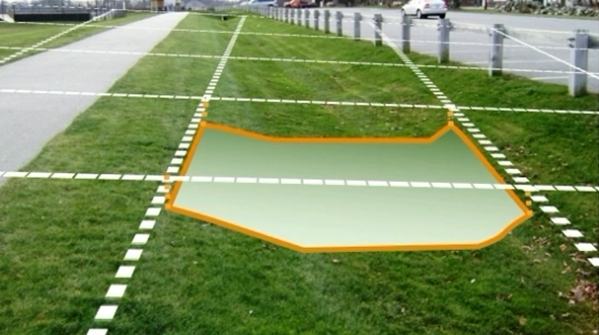
Image: Sample elevations at fine resolution across whole cell Source: https://megamanual.geosyntec.com/npsmanual/waterqualityswales.aspx
These days, both aerial and terrestrial LiDAR data are available in increasingly high resolution, but the vast majority of the information is not commonly used in hydraulic modelling.
2D hydraulic modelling software such as TUFLOW will traditionally sample the underlying digital terrain model (DTM) by taking the elevation measurement at the centre of the cell (as well as cell face midpoints in TUFLOW’s case), or by taking an average/minimum of the underlying DTM elevations as the cell elevation. 2D hydraulic model grid cell sizes are usually 2-10 times the size of available DTM cell sizes, so the sub-grid scale topography that may be present in the DTM is not utilised within the 2D hydraulic model.
Improved representation of detail within open channels is one of the reasons that one might choose to represent open channels using 1D hydraulic modelling, or use flexible meshes, both of which are significantly more time-consuming to set up correctly compared to a regular fixed grid.
With SGS, rather than using a single elevation value for the grid cell elevation, underlying DTM cell elevations can be used to determine a water surface elevation vs volume relationship for each grid cell. A similar action is performed along the cell faces, resulting in the full array of information in the DTM still being utilised within the 2D hydraulic modelling despite the hydraulic model grid resolution. This improves the representation of the underlying topography and the accuracy of simulated results.
Traditional Approach vs SGS Approach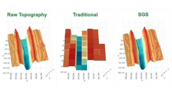
Traditionally, surface area would be broken up into cells, and the elevation data associated with a cell would be extrapolated through sampling a single elevation from the centre to create a square tub that holds water. From there, to see how the water moves around from one cell to the next, a single elevation in the middle of the cell side would be sampled, and a flat rectangular section used.
Often this coarse representation of the underlying Digital Elevation Model (DEM) or Triangulated Irregular Network (TIN) would miss out key features.
With the SGS approach, however, sample elevations can be taken at fine resolution across each cell – across the whole cell. Instead of a single point, a relationship or curve can then be generated. This is effectively the cell volume with height, and the flow area for each cell side. This method provides a far better representation of what’s inside the cell – i.e. a much closer representation of the DEM or TIN.
Benefits of Sub-Grid Sampling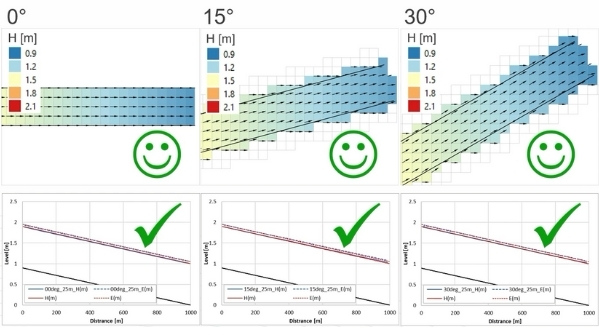
SGS improves flow depth estimation accuracy at stormwater pipe network inlets, and increases the accuracy of flows entering stormwater pipe networks.
The previous way of dealing with the issue of coarse resolution – using very small cell sizes – caused very long run times and large output files.
With SGS, we get:
- Consistent results for different cell sizes, meaning we can use larger cell sizes, giving faster run times
- Consistent results for different orientations (i.e. you no longer have to align the grid/mesh with the gutter)
- No need for gully lines (can now be detrimental)
- More accurate inlet flow capture
Elimination of numerical loss effects associated with oblique, coarsely represented steep-sided channels leads to improved above-ground result accuracy.
More accurate representation of above-ground topography means faster stimulation as models can be built using larger cell sizes.
We also see improved flow depth estimation accuracy at 1D inlets, which leads to more accurate storm water network results.
In addition, by using the underlying sub-grid scale topography, it is possible to more accurately represent the potential storage and conveyance within the system being modelled.
The use of sub-grid sampling can also assist with model calibration and is particularly useful for whole of catchment direct rainfall models.
The amazing benefit to modellers and workflow efficiency is that the modeller can calibrate a model and the calibration can still be valid when grid resolution is changed.
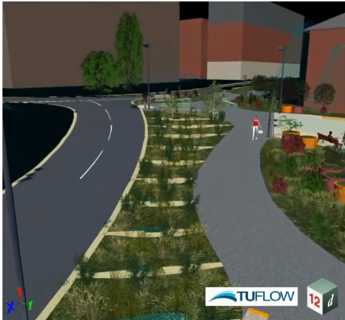
What is Quadtree Mesh Refinement?
The Quadtree grid shown here for the Water Sensitive Urban Design (WSUD) device refines in two simple steps – from the road/path straight to the detailed grid in the WSUD device.
Quadtree is the simple concept of splitting one 2D cell into four, over and over again – allowing your 2D model to have variable cell sizes based on subdivision of your square cells, down and down. With Quadtree, you can refine your model resolution whenever and wherever you want, to achieve improved accuracy.
Quadtree is very easy to set up – this can be done either by using existing polygons like a road layer or by drawing polygons to define nesting and giving each polygon a level or resolution. Currently Quadtree can accommodate up to 9 levels to nest down into, one level at a time (more than enough for everyone who’s used it so far). If you want to skip one or more levels, Quadtree even automatically transitions.
With the inbuilt automated level approach, you can simply skip to the desired level and TUFLOW will auto-buffer one cell for each skipped level.
The advantages of Quadtree are, among others, that it allows you to get refined results where needed, it’s very easy to set up, and it provides faster simulations due to fewer 2D cells (run times typically decrease by 2 to 5 times). Quadtree also enables refined representation of topography features and hydraulics where the user desires.
So far, no disadvantages have been found unless run-times increase because your non-Quadtree model is at a different resolution.
SGS + Quadtree Combination
In the urban world, the capturing of inlet flows is far more accurate, plus we achieve higher resolution modelling (in terms of flow patterns) with these two combined. This means we can be much more realistic with our modelling. It’s a real game-changer.
With sub-grid sampling, despite using larger grid cell sizes, the underlying topography is still used. Results using coarser grid cell sizes and SGS are comparable to those using a much finer grid cell resolution at a fraction of the computational effort, and data storage.
Used in conjunction with TUFLOW’s Quadtree solver to allow the user to focus detail where required without compromising computational efficiency in locations of little topographic variability, SGS can be used to ensure areas of coarser grid cell resolution, still providing the necessary detail for robust 2D hydraulic outputs.
SGS and Quadtree into 12d Model
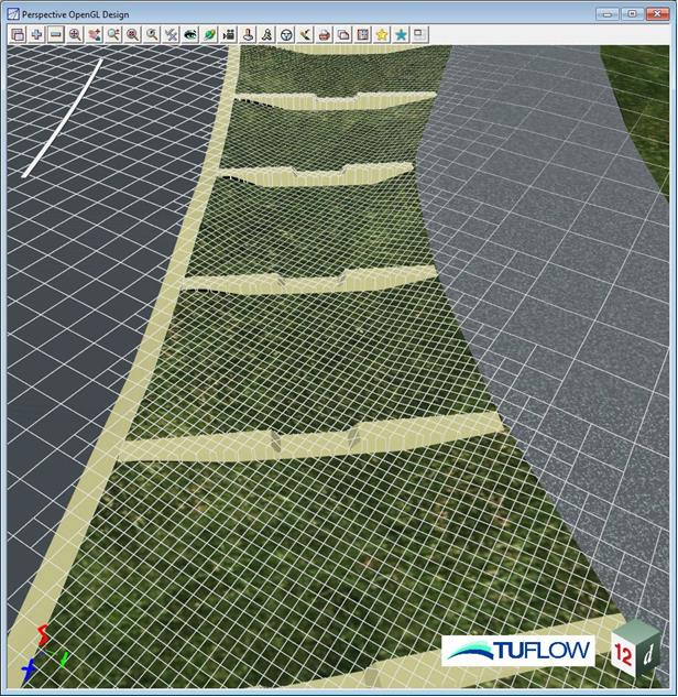
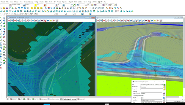
How does 12d Model implement SGS and Quadtree? Boundary Polygons wrap a polygon around a set of strings in a view.
Then in RoadFlow, we enter the TUFLOW road extent and set the SGS frequency, plus specify the Quadtree model. Roadflow also handles AR&R storms.
Non-Newtonian Dam Break
With non-Newtonian flow, fluid no longer behaves like water – viscous characteristics change as forces are applied. For example, tailings can liquify when subject to gravitational forces from a dam failure, and paint becomes thinner as you force it with a brush.
These events can now be simulated in TUFLOW. AS always, results may be animated using 12d Model Visualisation via Timelines.
Modelling Bridge Decks
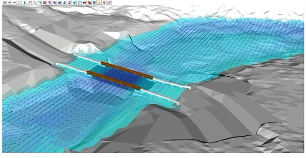
This has always been somewhat problematic.
TUFLOW, together with TMR Queensland, set out to find a way to improve bridge deck representation in flood models to reduce uncertainty of hydraulic model results, leading to better bridge designs.
To do this TMR have been doing a range of modelling – CFD (incredibly high resolution) and TUFLOW, as well as other benchmarking and comparison testing using measured data.
Conclusion
SGS and Quadtree combined have become a real game-changer for urban modelling. This approach is allowing users to really drill into detail to model roadways, round-abouts, channels, SUDS and WSUD features, in detail and with fine resolution.
Inlet flow capture is much improved, and in terms of modelling roads and gutters, it really does help enormously as well.
References:
- 12d Model TUFLOW Training: www.iscdt.com.au
- TUFLOW tutorials: https://www.youtube.com/channel/UCZuGrIP8ayOwC1ojmnZrgPg
- Source: LinkedIn article by Duncan Kitts – UK/Europe Software Lead at TUFLOW
- Source: Chris Huxley from TUFLOW, in a webinar given for 12d Solutions in 2021