Overland Flow and Flood Extents
I caught up with Owen Thornton of 12d Queensland for the fifth episode of his Stormwater Drainage Design Fundamentals series: Overland Flow and Flood Extents.
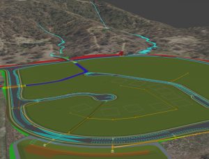
Owen demonstrated the Water Network Editor being used to establish links between water networks and overland flow strings. The water networks were then analysed to produce 3D models of the flood extents, relative to the surface model, indicating the combined effect of catchment runoff and bypass flow rates. This step is fundamental to achieve a design with a nominated immunity, and to verify that inlet nodes are properly located to control the overland flows.
This series of training webinars covers the basic and intermediate aspects of the Water modules in 12d Model 14, with special emphasis on the design of stormwater drainage. It is presented as a condensed overview of the material normally covered in the first two days of the formal Three Waters training courses (W01 to W06) offered regularly by 12d Solutions. This material is assumed knowledge for many of the more advanced training courses available in the 12d Water suite.
A construction-ready drainage model – including catchments, pits, pipes, culverts, channels and flood extents – is created from scratch in 3D and designed for specified minor and major storm events using the Rational Method. Output plans, long-sections and calculation tables are also produced.
For easy reference, here are the links to our blog posts from the previous episodes in this series: